 Asset Publisher
Forests of our Forest District
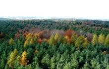
 Widok z wieży na Zielony Las. Fot. Damian Sandak
 Tęcznik mniejszy. Fot. Michał Szczepaniak
 Głóg w zimowej szacie. Fot. Michał Szczepaniak
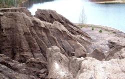 Żleby, powstające na wysokiej krawędzi zbiornika, w obrębie antropogenicznych skał nadkładu. Fot. Damian Sandak
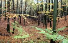
 Lasy mieszane. Fot. Damian Sandak
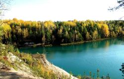 Zbiornik wodny na geościeżce w okolicach Łęknicy. Fot. Magdalena Lewandowska
Lipinki Forest District Inspectorate manages the area of nearly 24 500 ha, which is a habitat for many protected species of plants and animals.
The Forest District includes three Sub-districts: Lipinki, Żary and Trzebiel. Forests cover the area of nearly 23 200 ha including both, forests protected due to their damage or scientific value and forests maintained for industrial purposes, being the main source of timber for industrial production.
Landscape
Most of the area consists of plains or undulating terrains with minor and major hills. Altitudes range from 91 m above sea level in the vicinity of Olszyna to 227 m above sea level in the area of Żary.
The area south of a little town called Żary is known for a number of dry valleys which fill with water only during spring melt or heavy rains.They were formed by the glacier and can be found on the area of end moraine in the vicinity of Olbrachtów, Mirostowice Górne and Mirostowice Dolne.
Influence of the glacier can be admired in the western part of Lipinki Forest District.One of the most impressive forms of moraine landscape – Wał Mużakowski (Muskau Wall) – can be observed in the vicinity of Trzebiel.
Muskau Bend (Łuk Mużakowa)
The most impressive form of landscape to be admired in the Lipinki Forest District is end moraine taking the shape of a horseshoe open in a northward direction.
Muskau Bend is a fine example of accumulated end moraine.It consists of parallel ridges and depressions.This interesting landscape ranges along the entire western area of Lipinki Forest District – from Tuplice to Łęknica.The bend area is also full of water bodies.